#feministfriday episode 468 | on your way
Good morning everyone,
Today marks nine years of Fem Fri. It started as a link I sent to some favourite colleagues two companies ago, and because it happened to be on a Friday I called the email #feministfriday. I or a guest editor (thank you, guest editors!) have issued it every week of the last nine years, and I've been thinking about this for a while, I'm going to stop at the decade. Episode 520 will be the last episode. We have another year together. Thank you for being a part of it.
In further admin notes, I'm away for the next couple of weeks, so the excellent Margo Howie, co-founder of Space Fruit Press, will be your guest editor. THANK YOU MARGO, I am excited to see what you do with the place.
Now let's enjoy some maps together. Here's Marie Tharp, whose work proved the theory of continental drift:
For years, Heezen collected the data while Tharp crunched the numbers and charted them out. It was thankless work in a time before computers; Tharp had to comb through an enormous pile of sonar soundings and plot out her measurements by hand. Still, she found inspiration in the very mystery of the task. “The whole world was spread out before me,” she recalled in a 1999 essay about the Lamont-Doherty Earth Observatory. “I had a blank canvas to fill with extraordinary possibilities … It was a once-in-a-lifetime—a once-in-the-history-of-the-world—opportunity"
https://www.smithsonianmag.com/history/seeing-believing-how-marie-tharp-changed-geology-forever-180960192/
Irene Fischer fled from the Nazis, lived to 102 and knew a heck of a lot about the shape of the earth:
Fischer became internationally recognized […] during the Mercury and Apollo moon missions. Her Mercury Datum, or Fischer Ellipsoid 1960 and 1968, and her work on the lunar parallax, were paramount to conducting these missions. Fischer was a pioneer [… and] the first AMS employee […] to receive the Distinguished Civilian Service Award for her work.
https://www.nga.mil/news/Women_in_GEOINT_Irene_K._Fischer.html
Maybe a Fem Fri First, a link to a dot mil domain. Probably not going to make a big habit of that. Irene Fischer was cool though.
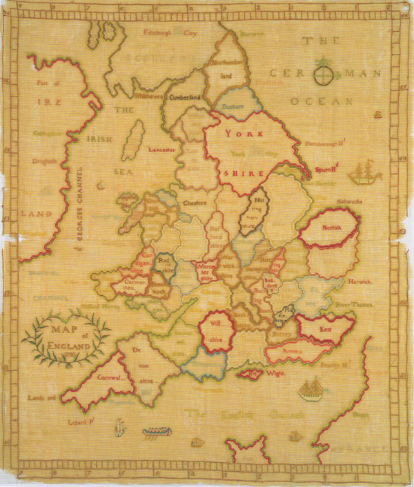
As regular readers know, I have long been a fan of samplers from history, but did NOT know that maps used to be included in that too!
In the eighteenth and nineteenth centuries young girls would work, or embroider, the alphabet and a phrase or maxim on a piece of woven cloth (typically) with silk thread (usually) in order to learn the rudiments of the alphabet and grammar, and to practice and improve their needlework skills. Within the universe of these samplers there is a unique subset of “working maps” or map samplers. Color Plate 1 provides an example of a map sampler made in the 1770s. The counties of England were worked in silk thread on fabric by 13-year-old Ann Rhodes for her school geography project. The sampler includes place names, marks for latitude and longitude, a compass rose, and a variety of ships. Thus, a project that typically would result in a paper product is instead rendered in a new medium.
https://cartographicperspectives.org/index.php/journal/article/view/cp82-trifonoff/1447
Love,
Alex.